04 Dec 2023 - {{hitsCtrl.values.hits}}

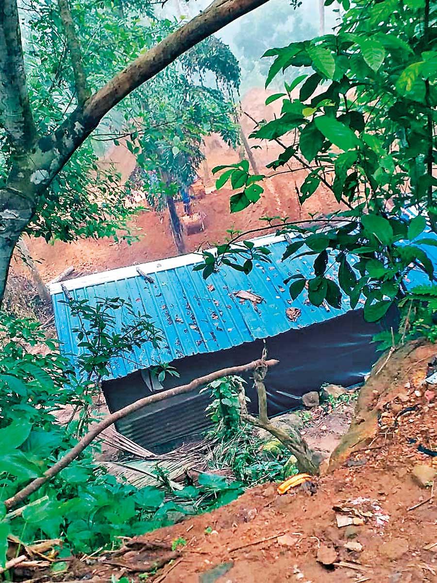
Mining activity taking place near an area prone to landslides
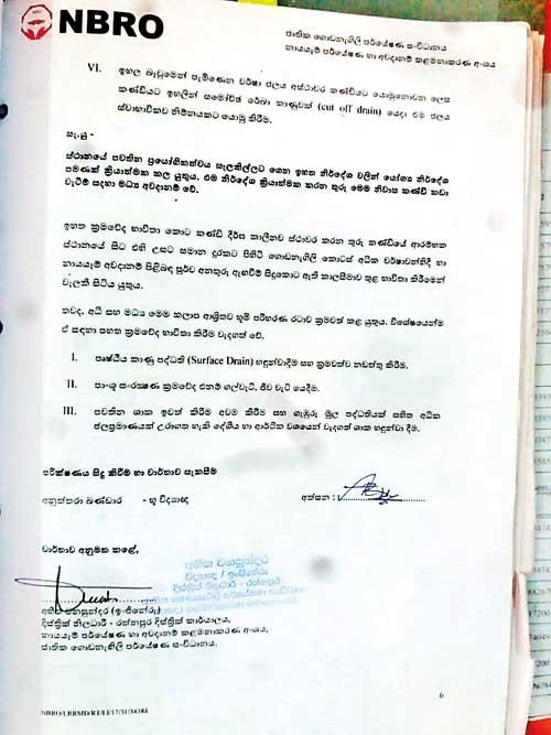
Due to the prevailing heavy rainfall during the past few days, warnings of landslides have been issued in various parts of the island. They serve as precautionary measures to mitigate severe damages to residences in the area. However, past instances have shown that disregarding such alerts has resulted in numerous casualties. This article is about a government institution permitting gem mining through the use of backhoes in an area exposed to a high risk of landslides. The mining activities are taking place during this rainy season putting lives of people at risk. This mining activity is taking place in Ratnapura. The Landslide Research & Risk Management Division (LRRMD) of the National Building Research Organization (NBRO) alerted the public on October 7, 2017, about a landslide risk in Medagalatura and Galkerakanda areas of Sinhalagoda Grama Niladhari Division in Ayagama Divisional Secretariat of the Ratnapura District. This warning followed a preliminary ground survey conducted in response to ground instability experienced on May 26, 2017, in the area. The associated reports were issued as NBRO/LRRMD/RT/L117/31/32559 and NBRO/LRRMD/RT/LI17/31/34384. Engineer Abhitha Vanasundara, District Officer of Ratnapura District Office of NBRO’s Landslide Research and Risk Management Division approved and signed these reports.
The main road from Ayagama to Idamgoda runs in this area; serving as a route for about ten thousand individuals who commute daily. This road is used by those heading to Colombo, individuals employed in Ayagama town, school children commuting to Ayagama town and those engaged in both private and government jobs and people who are involved in Ayagama fair. Given its substantial usage, the road serves as a main road. It is also the easiest route to Egaloya, Bulathsinghala, Kalawana, and Matugama via Ayagama. Furthermore, the road facilitates the ambulance service from Ayagama Hospital to Ratnapura General Hospital, and it is frequently used by doctors travelling on this route.
Against this backdrop, the NBRO conducted a survey regarding the ground instability that sprung up in the Medagalatura and Galkerakanda areas on this road; aimed at preventing a major disaster. Following the survey, the NBRO provided relevant recommendations in accordance with Circular 2011/01. The report issued by the NBRO notes the participation of Geologists Anuththara Bandara and Indu Ratnayake, and the then GN officer of the area, M.A. Siritavathi, in this survey.
We have submitted a report regarding the landslide area after carefully investigating it. A thorough on-site investigation was conducted at the mining site. The licence was issued after confirming compliance, and this process is overseen by the Gem and Jewellery Authority
-Abhitha Vanasundara, Engineer District Officer of the National Building Research Organization
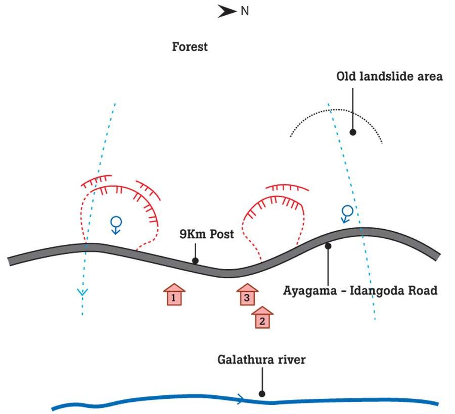
 Accordingly, three houses at high risk of being affected by landslides have been identified. The NBRO outlines the recommendations and conclusions from that survey as follows: “With the heavy rains on May 24, 25, 26 in 2017, the pore water pressure within the ground increased; leading to the development of landslides through the release of the surface soil layer on the slope. Simultaneously, the slope became unstable due to water pressure, resulting in the occurrence of landslides. The report indicates that the following factors contributed to this occurrence. The report further shows that unstable slope cutting and failure to stabilize earth near the base of the slope, with an inclination of more than 35 degrees, coupled with the existing geological and hydrological topographical features of the area, may exacerbate the instability in this area when the upcoming rains arrive. The report also mentions the risk of full or partial damage to houses located at the bottom of the slope. Additionally, the instability occurring from time to time along the two earmarked valleys can be identified, and there is potential for further development of instability. The report highlights the absence of an exit route for houses in the unstable area, as the risk of landslides from both the bottom and the top is possible with the flooding of the Galathura River during heavy rains.”
In addition, as recommendations, the report points out that three houses located in the area prone to landslides should be relocated. The houses are situated in close proximity to the previously mentioned site where the landslide took place. Therefore, the report states that there is a high risk to the houses of N. Ishan Upatissa, Y. R. Padmasena and Y. R. Gayan Sameera due to the presence of landslide debris. The report states that there is a risk of a flood due to heavy rains and concerns due to the lack of an evacuation route.
The report also notes that due to the current instability of the land, inclinations and cracks have developed around it. Additionally, the report indicates that the houses of P.A. Rupa, Y.R. Kularatne, and Y.R. Asanka Sandaruwan are situated in a medium-risk zone. Nevertheless, these houses are situated around mounds exceeding 1.5 metres in height. The report advises against using these houses during heavy rain due to the insufficient safe distance between the mounds and the houses. Furthermore, the houses of C.D.M. Senaratne and G.A. Vijithananda are identified as being in a newly developing landslide zone. According to the report the house of Helen Loretta Thisera is situated in an area where the new landslide debris will be deposited.
According to the report, since 2017, all the institutions responsible have advised residents to evacuate their homes and move to safer locations due to the risk of landslides in the area
|
Mining activity taking place where there are warnings for landslides |
during heavy rains exceeding 80-100 mm. Despite those warnings, Engineer Abhitha Vanasundara, the District Officer of the National Building Research Organization, who prepared and approved a report naming the area as one exposed to the high-risk of landslides during heavy rains, has taken an unusual step. This involves granting permission to initiate gem mining using backhoes on private land identified as at risk of landslides in the areas Medagalavathura and Galrurakanda. This permission has been given through a licence issued in the name of Thissa Jayawardena, a local gem businessman in the area.
The NBRO, responsible for providing reports on landslide risks in the area, prohibits any development activities by residents due to the danger of landslides. P.A.L.S. Ariyadasa, facing the risk of landslides in Medagalatura, questioned both the NBRO and Ayagama Divisional Secretary regarding how a local gem businessman received approval to operate gem mines using backhoes in the area, despite there being strict regulations prohibiting such activities. The NBRO, turning a blind eye to his inquiry, granted permission for gem mining using backhoes on the private land owned by the gem businessman Tissa Jayawardena. His land is situated in a landslide-prone area. Earlier, attempts were made to carry out gem mining using backhoes, but residents raised objections claiming that the area was exposed to the high risk of landslides. Ariyadasa said that mining activities were halted back then.
However, at present, despite numerous objections and without recommendations from other government institutions, Jayawardena has been granted permission to conduct gem mining in areas prone to landslides; solely with the approval of the National Gem and Jewellery Authority of Sri Lanka (NGJA) and the National Building Research Organization (NBRO). It has been reported that support has been obtained from two landowners whose lands are situated near the landslide site. Subsequently, Ariyadasa wrote to the NBRO office in Ratnapura inquiring into this matter, but as of now, no response has been received. During his visit to the office, an officer had informed Ariyadasa that for a brief two-month period they were allowed to excavate mines using backhoes under certain conditions, for testing purposes. Ariyadasa said that, when inquiring from the Ratnapura Gems and Jewelry Authority, they had stated that permits for mining with backhoes were issued based on recommendations from the NBRO.
Ayagama Road is situated 150-200 metres from the Gangathura River. The mining site is about 50 metres away from the hill prone to landslides on the opposite side of the road. Ayagama Road is 20 metres from the location where backhoes are being used for excavation. Ariyadasa said that despite claims of using backhoe machines for mining near the river, these activities are taking place in an area identified for being prone to landslides and this factor is evident to anyone visiting the site.
Our responsibility is to provide a report only when someone lodges a complaint. The Divisional Secretary sought information from me about the area where mines are excavated using backhoes, considering it a high-risk zone for landslides, and I provided that information”
- M. Premachandra - Grama Niladhari Sinhalagoda GN Division

Regarding these concerns this newspaper approached Vanasundara. He stated that there is no connection between the location of the landslide and the mining area. “Backhoes are positioned on the bank of the river and not in areas exposed to the risk of landslides. We have submitted a report regarding the landslide area after carefully investigating it. A thorough on-site investigation was conducted at the mining site. The licence was issued after confirming compliance, and this process is overseen by the Gem and Jewellery Authority. “If mining is conducted in violation of the conditions set by us, the Gem and Jewellery Authority has the power to take appropriate action. Please inform us if any activities go against the recommendations we provided. I will deploy a team to address the situation. We are willing to take responsibility in the event someone faces death while engaging in mining at that location,” said Vanasundara.
He also stated, “I have not visited this location. According to the report provided by my officers, we granted permission for mining under certain conditions. The Gem and Jewellery Authority requested this recommendation report from us. However, if they violate the conditions we stipulate, we are unable to take any direct action because our role is advisory in nature and we urge them not to violate the conditions laid out. We have outlined 10 conditions. Additionally, besides our report, recommendations from other institutions are required. Approval from the local provincial council, Divisional Secretary, Irrigation Department, and other relevant institutions must be obtained. Backhoes are being used for mining at a distance of 61-88 metres from the previous landslide site. Permission has been granted to excavate deeper until the gem-bearing gravel is reached. Three houses deemed to be at high risk have been relocated from the landslide site.
“There are three houses exposed to a moderate risk of landslides and backhoes are being used for mining in close proximity to these residences. We need to hand over reports to the Gem and Jewellery Authority. They are responsible for monitoring landslide risks and addressing concerns. There is a potential risk of landslides, so the Gem and Jewellery Authority should be overseeing that area. We submitted this report in May and the Ayagama Divisional Secretary inquired about it in November,” Vanasundara said adding that he is not prepared to respond regarding a report submitted in May.
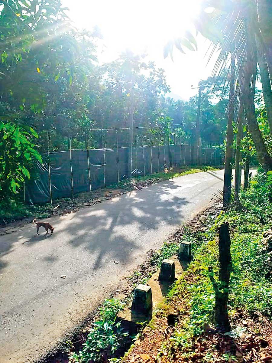
M. Premachandra, Grama Niladhari of Sinhalagoda GN Division, commented on this matter. He had the following to say: “We have not provided any reports to permit the excavation of these gem mines. It is not under our purview. The National Building Research Organization and the Gems and Jewelry Authority are the entities that recommend backhoe excavation. Our responsibility is to provide a report only when someone lodges a complaint. The Divisional Secretary sought information from me about the area where mines are excavated using backhoes, considering it a high-risk zone for landslides, and I provided that information. This area has been named high-risk since 2017, and is surrounded by landslides on three sides — the North bordering the land of Helen Loretta Thisera and the West bordering the land of D.M. Senaratne. Helen was granted 1.6 million rupees to build a house elsewhere. That is where these mines are being excavated. The houses at high risk of landslides are situated 20-30 metres away from the mining site. They cordoned off the road and the nearby area with black tape. The distance from there to the other house exposed to the high risk of landslides is less than 100 feet,” he added.
When this newspaper questioned gem businessman Jayawardena about this issue, he said, “I have been granted permission by the National Building Research Organization. There is no need to seek approval from other institutions. We followed the instructions given. If you have more questions, talk to my manager,” He suggested that we make inquiries with the Gem and Jewellery officer to obtain further details.
We don’t offer recommendations to any location deemed as a high-risk site. The GSMB cannot provide recommendations for gem mines. We have not recommended the use of backhoes for mining in a high-risk landslide area
- Chaturangi Godagama - Engineer Bureau of Geological Survey
and Mines
Upon inquiring from the Ratnapura Irrigation Department, they denied that Jayawardena or the Gems and Jewellery Authority were granted permission to use backhoes for mining in the Medagalatura area, where there is a risk of landslides. The Irrigation Department also confirmed that they did not receive such a request.
Ayagama Divisional Secretary Sanjeevani Kandambi, when spoken to on this matter, said that obtaining permission from the Divisional Secretary is not necessary to use backhoes for gem mining or on a private land. She also said that neither the Gem and Jewellery Authority, the National Building Research Organization nor Jayawardene has requested for any recommendation regarding gem mining using backhoes at a high-risk landslide site. Although a resident from the area made an inquiry, the National Building Research Organization was informed about it, but she has not yet received a response, she added.
When this newspaper questioned Engineer Chaturangi Godagama from the Bureau of Geological Survey and Mines, this newspaper was told that recommendations are obtained from the National Building Research Organization when issuing permits for excavations in areas prone to landslides. “However, we do not offer recommendations to any location deemed as a high-risk site. The GSMB cannot provide recommendations for gem mines. We have not recommended the use of backhoes for mining in a high-risk landslide area.” she added.
When this newspaper made inquiries from Secretary of Ayagama Pradeshiya Sabha, D.G.S.S. Ariyasinghe, he said that they have not granted permission to Jayawardena to use backhoe machines for mining in the Sinhalagoda area. Ariyasinghe added that if there were concerns regarding landslides, a request for a recommendation should be made to them. Ariyasinghe added that no such request had been received.
Despite repeated phone calls given to the Ratnapura office of the National Gems and Jewelry Authority on both November 22 and 23, 2023, there was no response. They deliberately disconnected the line when this newspaper called:s and the receiver was left aside. However, on the evening of November 23, we received information that mining in the high-risk landslide zone using backhoes had been temporarily halted.

The main road leading to Ayagama
22 Dec 2024 1 hours ago
22 Dec 2024 1 hours ago
22 Dec 2024 4 hours ago
22 Dec 2024 4 hours ago
22 Dec 2024 4 hours ago